Monday, June 30, 2008

Derby

The caravan park at Derby was filling fast on 21 June, and we joined a queue of patient nomads desperate to unhook and get into the laundry. Tony had prepared them for our arrival, so we set up next to each other and we at least made a show by washing the accumulation of Kimberley dust and mud off. We headed to the wharf where we made a booking at the restaurant, in hopes of finding some good barramundi. The tide in Derby is the biggest range anywhere in Australia, and compares with those found in the UK, at 12 metres. We leant over the railings to see the surge of water eddying around the piles; brown as tan boot polish. With the tide risen, and overlooking the lit up wharf buildings across the water, we enjoyed a good meal, if not yet the Barra we search for. Getting staff for Derby’s best eating place is so shaky they teeter on closing. The owner, Phil, described the difficulties faced by traders in a state where the miners are distorting the whole economy with big payouts. Our waitress was in fact a rock crusher from Cockatoo Island earning $90K a year, home for a fortnight earning pin money. The dining table view was however stunning.

Derby is a sorry place. Surrounded by mud flats and mangrove, it would have been a most challenging outpost of humanity a century ago. Broome was and is the centre of the pearling industry and demand from overseas immense. Sadly, aborigines were forcibly taken from areas such as Windjana, to be divers, alongside the Japanese, Macassans, Chinese and others who voluntarily worked at this most dangerous activity. The death notices of the time seem to be the bends or berri berri. The Pioneer Cemetery (pictured) is full of people who met an “accidental” death at age about 30. The open sided gaol in Derby is where aborigines and witnesses to crimes alike, were gaoled until a magistrate would appear, sometimes six months later. They were unprotected from the elements apart from a roof over their heads. So Derby’s highlights (apart from an excellent pizza) for me anyway, were rather grim and I was happy to leave it behind, in favour of the delights of Middle Lagoon.

Friday, June 27, 2008

Technology and travel


At the halfway mark camped in one of the remotest parts of our journey I (Helen) am reflecting on the role and advantages or otherwise of the technology we have chosen to use on our trip. By this I mean telecommunications; the Prado obviously has its own high tech in the form of tyres plus compressor and deflator, suspension modifications, UHF radio, etc deemed essential. (Tyre pressures area very serious matter and source of much debate in all places drivers gather). Not to mention an entire industry devoted to all the tweaks possible for camper trailers and caravans. We decided to save expenditure and live without GPS (global positioning system), or an EPIRB (emergency position indicator radiating beacon!).

A satellite phone was also an expense we have so far decided against - renting for 2 months was not considerably cheaper than a purchase price of well over $2000 and nearly all routes in Australia have travellers – TCCC members
will be able to imagine Jack Beach’s voice telling me “Mate, a week’s worth of baked beans, plenty of water and spare tyres will see you through – tell the police before you go and when you arrive so they know when to start looking for you”. The sat. phone issue is still being debated for the last leg – the Anne Beadell Highway across the Great Victoria Desert from WA into SA. I can see it would be worthwhile if more remote travel is on the cards, as it will be. Most desert travellers have one as mobiles certainly don’t have coverage there. We spent an afternoon at King Edward River on the Mitchell Plateau yarning to a delightful elderly Scot travelling alone (his wife had finally jacked up and bought a $1000 pup so she could stay home to see grandchildren grow) : he’d had 3 strokes and a heart attack; his daughter had bought him a sat. phone and he reported in regularly at $3.84 per 30 seconds or $2.50 per SMS.


What I am glad to have brought with us are:

1. Laptop computer. As my hand writing is so appalling I figured it would make more sense to type a diary, but guess what? I’m up to a second exercise book of day to day scribble as haulin
g out the computer is too much hassle every day, and I can’t type as fast as I write. It is fantastic being able to download photos from the digital camera to the laptop and sort, label and view them in various ways. The laptop becomes indispensable teamed with:

2. Wireless broadband. This is via a small device called a data pack which plugs into the laptop with an extra antenna if needed, and thanks to Telstra I have one with unlimited downloads to which I am addicted and eternally grateful for, not having to worry over counting megabytes while downloading all our emails and loading photos and blog updates. Turning off the very hungry auto-updates is a good idea nonetheless. A nextG mobile could also be used as a modem in a laptop. Wireless broadband is accessible in surprising places, for example sitting here halfway up the Dampier Peninsula at an Aboriginal owned and run ocean-side retreat/resort/camp called Middle Lagoon. I also saw the same operation at the community store of the remote Aboriginal community of 60 Bardi people at Lombadina yesterday. Albeit in both places connection is a bit sporadic, dropping out at inconvenient moments. And I talked to a dentist in Derby who travels the deserts as a locum and relies on laptop with wireless broadband via a modem for all his access (he also uses a sat. phone and GPS.)

Having an internet-enabled laptop enables one to avoid the hassles of searching in towns for a library or Internet cafe (and don’t get me wrong, these are essential services I and others have long argued for), to access email, pay bills, transfer money to the ever-diminishing bank account (plastic cards take a beating at $2.00+ per litre for diesel on long journeys). Not to mention THE BLOG. This can be a bit of a mixed blessing. The advantage is that by posting news available to anyone you feel less inclined to be under pressure to send emails or postcards to individuals (who I hope are not hurt by their lack!) The downsides are the pressure of taking the time necessary to write posts (though Ian seems to have willingly taken this role and observes that blogging is an enjoyable distillation of experiences), and do battle with blog software to post text and photos (I use Google’s free blogger and its Picasa photo storage which can be fussy, but allows more storage capacity than BigPond’s free blog). Finding a powered campsite occasionally to plug in the computer and charge its battery was an imperative – (I well remember being propped on a broken washing machine in Kununurra using power from the laundry!) until we became more confident that it will work off the car battery via an inverter (which converts Direct current power to Alternating current) - the first time it threw a wobbly and froze but now we recognise the symptoms via a beep about overheating or low car battery.

3. A blue tick nextG mobile phone. Telstra Countrywide kindly supplied a Country 165 model with car kit with assurances that this would give maximum coverage. And so it may - the 98.4% coverage figure used means population, not area. Any glance at the maps available on the Telstra website quite clearly show the large areas not covered by nextG which is focussed on population centres and highways. Some people still swear their older 3G mobiles still work in areas not covered by nextG. Which brings me to the inescapable conclusion that payphones are still a vital part of our telecommunications system. While the availability of fixed line or satellite phone and internet access to remote stations and tiny towns (eg along the Oodnadatta track and in the Kimberley) is truly remarkable, for the ever increasing numbers of travellers and transient workers payphones are really the only option, as they are for many Aboriginal outstations. For example, at Australia’s smallest town – William Creek with a population of 4-6 on the Oodnadatta track - all action of course is centred at the pub which the publican told me 65,000 cars pass each year; the Telstra payphone outside (pictured) is their only communication possible unless they have satellite phones. A $10.00 phone card provides a much cheaper way of keeping in touch, let alone make an emergency call. Incidentally, the emergency worldwide number is 112 - if outside your mobile network coverage, in an emergency dial 112 and the mobile will search any existing network.

Nonetheless, a mobile seems now to be an essential piece of hand luggage, and it has been a boon to be able to ring from the car to the nearest Toyota dealer to chew over a problem as we did outside Katherine, or make a booking for a service as we did outside Alice Springs, or take a photo and send to the kids via a month’s free MMS, or SMS new friends met on the road.

One of the joys of being on holiday is to switch off and forget such things as work, accounts, debates about technology, and cut off from news from the “outside world” – we have felt very little urge to read newspapers or look at online news. There is also sometimes a tension in how removed you want to feel from family and friends. On balance, I guess we are very lucky to have choices about how much or how little you engage, or do research, and what risks you take, and telecommunications remains a critical factor in all choices.

Thursday, June 26, 2008

Kimberley part 3: Bell and Windjana Gorges, and a sorry tale.


Leaving our favourite watering hole was made easier with the thought that “we will return”, and the prospect of more delights ahead. Engorgement continued as we headed back to the Gibb River Road, turned west again, and aimed for Bell Gorge, a long day at 380 kms over dirt. The journey was broken in the usual way, including a stop for fuel at Mt Barnett roadhouse, a short walk into Galvan’s Gorge (a delight with another swim and Wandjina face discovered under a rock ledge), and a stop for paddle pops at the Aboriginal community at Imintji. This is a charming roadhouse with good facilities and lots of laughter from the locals – a positively rare thing, but as almost always, a white couple running the place. Behind the scenes, a wrecked Toyota in every yard and for me, frustration and a sense of abject failure to understand how we should more properly engage. The day’s journey ended 10kms short of Bell Gorge at a ma
gic site called “Silent Grove”.

We found plenty of space to stretch out in the “generator area” part of the park, away from families playing serious cricket and AFL (very popular throughout NT and WA). Just a few others quietly going about their chores. It had to be the couple next to us. They read all evening until well past lights out, illuminated by a single lamp mounted on the car, run by a Honda generator at full revs. We were touched by the purpose made acoustic baffle assembled around three sides of the unit; it was very effective at throwing the racket in our direction. Actually the Australian’s ability to ignore noise and make it at the same time has been much underrated.

However we were much refreshed and ready the next morning for the short drive and walk into Bell Gorge, with the now to be expected magnificent falls and swimming holes. It should be said that on the west end of the Gibb River Road, within cooee of Derby and Broome, even the smallest and difficult to reach watering holes were visited by tour groups of 15 to 20, travelling in magnificent 4WD coaches and led by drivers with extensive knowledge of the plants and animals and rock art to be seen. What a great job for the adventurous young and not so. It would test all your skills. Bell Gorge was followed with a turn off the main track, back south eastwards along the Lennard River and onto the Leopold Downs Rd that takes you eventually to Fitzroy Crossing and Halls Creek. Objective: Windjana Gorge and Tunnel Creek.

Australians didn’t learn at school of the warring that went on, much of it in the Kimberley, between white pastoralist and settler, and “the blacks” as they were called as recently as the the 20th century. It makes a very sorry tale, typified by the story of Jandamarra of the Banuba tribe. Nicknamed “Pigeon” as a young boy at the station he worked, he was regarded at an early age as one the Kimberley’s best stockman, also being an outstanding shot and horseman. After initiation at 15 he joined his people in attempting to drive out the huge flocks of sheep destroying the lowland country. The law made even the possession of wool an offence, let alone the killing of sheep or cow. But as wool was traded within and between tribes in ignorance of white man’s law, many aborigines were arrested for possession. Jandamarra escaped a jail sentence for sheep spearing by working for the police in Derby. Banished from Bunuban society for flouting traditional laws he went to live at Lillimiloora station near Windjana Gorge, working with Constable Bill Richardson as an armed tracker. When he was sent out to run down his own tribesmen, he ran into the obvious dilemma.

In 1894 he and Richardson, by then his friend, marched 16 Bunubans, some his family, in chains to Lillimaloora, but when they “got to him” he turned. While Constable Richardson was asleep, Jandamarra shot him, released his fellow tribesmen and made for nearby Windjana Gorge. Here he and his group were able to evade the law and form an organised resistance to the invading white man. Thirty five kilometres east of the gorge is an amazing tunnel that runs right through the Napier Range, known as Tunnel Creek. Badly wounded after a battle with police, Jandamarra hid here. In 1897 after other incidents including a murder of a white stockman and attack on a station, he was shot finally at the entrance to Tunnel Creek cave by another tracker. In those days of course he was regarded as a criminal of the worst kind and punitive expeditions by police reinforcements killed many Aboriginal people; today his motives are better understood and the words “freedom fighter” are to be found scrawled on monuments. Those who have seen the movie “The tracker” with David Gulpillil, and Gary Sweet as a constable, will get a feel for the times.

Windjana Gorge is cut by the Lennard River through a wall of Devonian coral reef that rises about 80 metres vertically out of the surrounding flat grassland. The effect is striking and scale large. The 3 km walk into and through the gorge, about 80 metres wide at its opening, takes you into a cool world away from the heat of the plains. Fresh water crocodiles are many and can be seen jaws agape and static on the banks, or gently cruising the still pools. Boab trees stand unclad and somehow aloof from the rest of the very varied vegetation. Their bulb-like trunks, often siamesed in twos or even threes, carry abruptly projecting branches and outer limbs that resemble a fig, but sport pendulous seed pods the size of a large mango. We have tasted the pulp inside these hard shelled fruit, which when chewed resembles a spicy pasta that is apparently nourishing. Kapok bushes, also with leaves shed, have set large yellow, waxy stellate flowers that shout at you.

I have spent time every day trying to shell out some better design solutions for the bits of the Tvan that irritate. As time passes I keep coming back to the thing as it is and agreeing with them, that it all works, and while a bit fiddly is cost effective. When we purchased the Tvan I went to the factory in the eastern suburbs, and met with Tony the salesman, who explained the ins and outs. We saw another Tvan at the site at Windjana and parked alongside. Up popped Tony with his wife Diane, and we have had several days with them since, there and in Derby. These chance meetings are part of the pleasure of holidays taken this way, and no, I have only bent his ear a little bit – and he seems to love it anyway, being a natural and knowledgeable salesman.

Backtracking to the Gibb River road, we soon passed the surprising Blina gas fields and arrived back onto the bitumen on our way to the civic pleasures to be offered at Derby. Our Kimberley adventure is over for this year, but there will be another as soon as possible. Not to be left too long as the encroaching bitumen means more and more people in this remote area.

Tuesday, June 24, 2008

Kimberley part 2 ; King Edward River, Mitchell Falls and thoughts on camping

I’m really impressed the way toilet roll is provided in campsites everywhere we go. One of the things you learn when travelling like this is how to manage paper that comes off a great roll, without those tear off bits. Trap the paper between the first and second fingers, then spool the paper around the hand. This accounts for the pathetically thin gauge it comes in, and ensures a level of satisfaction where these delicate matters are concerned. Toileting is something we gave a lot of thought to, and we even purchased a special tent for the purpose. So far we have had no need of it, facilities have been so good.

We have been lolling in fresh water pools for a long while now, but today we arrived beside the sea at Middle Lagoon, half way up the Ardi - Dampier peninsula, on the way to Cape Leveque. Driving 110kms south and west out of Derby, we turned onto an “unauthorised” dirt road that took us through savannah and sand for about 150kms further. At times the sand required planting the foot in third or second gear, to keep way on, but no trouble. You don’t expect to be actually camping almost alone overlooking the ocean, with a shady tree overhead, but we have it tonight at Middle Lagoon and I think we will stay a few days more here, as we don’t have to be in Broome until 3rd July to have the car serviced. So from now on the trip will be about beaches and salt crusty on the shoulders. We’ll perhaps put the solar shower to good use, although we even have showers here, all for just $30 a day, more for fly screened cabins. This is on Aboriginal land and they run the place; very laid back, but I think it will get busier over the next few days.

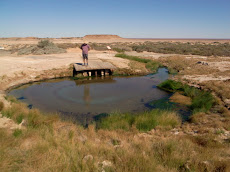
The fresh water pool at King Edward River back on Ngauwudu (Mitchell Plateau) was magic. The first day we were there I was paranoid about the wild life and wouldn’t pitch camp within 50 metres of the water. We set up under the best shade fairly close to the Clivis Multrum composting toilet, far enough away, and we were the only ones there. The afternoon was spent exploring for more rock art and we were successful, finding local Wandjina art which is dated back over the past few thousand years, with hints of much earlier Bradshaw, or more properly “Gwion” art that goes back at least 17,000 yrs and more. Wandjina figures are deities – ancestral rain spirits, with large eyes, like the eye of a storm, thin noses, no mouth, and usually with headdresses, indicating different types of storm weather. Large snake motifs are also associated with the Wandjinas. We also found a burial place in a small recess on a rock shelf, and another larger one at a second site. A few days later at this second site we came to these elegant, lively and we think incredibly beautiful Bradshaw figures - pictured at left.

Returning to camp we were amazed to find ourselves surrounded by a caravan of 13 Britz vans containing 26 hearty Dutch folk led by a weather beaten and very professional South African. They had the full on refectory table style dinner, replete with napery and proper glassware, and a sit down breakfast too. The campfire was lit and the night air resounded with the guttural guffawing of some very happy (and a little inebriated – why not?) Dutch folk. At 9:00pm they were all fast asleep thankfully. Of course they all, being Dutch, were careful to be regular, and every two minutes we were saying ”Good evening” as they passed by. Same again the next morning....”Good morning” we said. Well, a Clivis Multrum is a very good piece of alternative technology, but under these conditions the design parameters were greatly exceeded. I mean, there were 26 of them! They had curry for dinner. Circumstances downwind became dire. There were suddenly a lot more flies. The next morning the sight of the caravan moving off at regular 20 metre intervals was wonderful! As they stayed up at Mitchell Falls for a couple of days we ran into them again and again, and became quite good buddies.

Knowing they were at the Falls, we took a rest day and spent it searching for art that the South African had put us on to. We took off on a bearing through burnt grassy savannah, and found a long run of outcropping sandstone about 3 metres high. You get a bit of a feel for where the artist would have settled to do his work (it was always the men apparently), and sure enough, we came across some beautiful examples of Wandjina art, and again some small examples of Gwion Gwion (this means “the first ones” I believe. (To to the Mowanjum people near Derby they re Gyorn Gyorn - long ago ancestors before Wandjinas brought the law). Just no footprints anywhere – we were certainly the first this dry season anyway, to see the work. No one else that we spoke with knew of this site, and the S. African told us he normally would not have mentioned the place, but we seemed so interested. Covering our tracks we returned for a swim in our 500 metre pool, before tea (earlier paranoia being unjustified as no salties in this river). By now the campsite was empty again, and we had it to ourselves for the rest of the day.

The main purpose of this detour northward was to visit the Mitchell Falls, and to do this you must engage with one of Australia’s worst corrugated roads. The positive is that, after the King Edward, you only have to go 80kms on it to reach your goal on the Mitchell Plateau. With sunrise at 6 and sunset at 5:30, and two hours each way to drive, an early start was called for. We left at about 6:15 and were ready for the 3.5km walk to the falls by 8:30. This walk takes you through savannah, along the creek to Little Merten Falls where more rock art can be seen, then through woodland and monsoon patches across the head of Merten’s Gorge and Falls – an awesome drop of 80 metres in one fall, but only obliquely visible to us, and then on to Mitchell Falls. Mitchell’s is a series of small, medium, large then very large falls that step their way down, linking pools of different sizes. It is spectacular. What it would be like seen in the wet season is another thing again. You can only do this by air, preferably during a severe thunderstorm (no, not really). When you walk past the top pool where everyone is swimming, and on past the helicopter landing area (many people pay $95 and spent 5 minutes in the air, to be spared half the pleasure of getting there), to the best spot to look back at the whole of the falls, you find yourself perched above a series of large rocks with others below you, looking downwards at a crazy angle, feeling the vertigo coming on! It reminded me of being at the Melbourne Concert Hall in the upper reaches.

Each afternoon in the Kimberley temperatures rose to around 30-33 Celsius, with moderate humidity. We’ve found walking in these conditions fairly hot, rather like a good summer day in the UK, and regular water intake is essential, as is a good hat of course. So a stop on our return walk to sit under a little fresh water, falling in short steps and turns though the boulders and table like rock ledges at Little Merten Falls, was irresistible. Our timing was good, and we were able to negotiate the rocks and corrugations on the return trip without hassle.

Returning to a camper trailer camp is satisfying. There is a sense of semi permanence about it that a tent and scattered utensils doesn’t have. It’s quite homely and reassuring. Sitting under the awning now, looking out over the ocean towards Java or Bali or somewhere equally exotic, a gentle cooling breeze around the shoulders, under the full length awning, with her ladyship still languishing in her queen sized bed; I understand why so many folk make it a full time way of spending their days, after so many years punching the bag for someone else. The current price of diesel is a worry, and there are stories we hear of many “grey nomads” finding it difficult to stay on the road. Interestingly, some are taking low paid jobs as check-out chicks, or behind the bar, or running the campsite in far flung places where labour is otherwise unavailable, and finding themselves un-retired again, and quite enjoying the experience.

Sunday, June 22, 2008

Kimberley at last - the Gibb River road part 1


I can’t really believe that it is o
nly 10 days since the last entry. The pace hasn’t been too fast and we have taken several “days off” when feeling a bit tired. Certainly we could have visited many places that we have heard are special, but we’ve taken the view that if we do everything now things could get repetitive and we would be knackered. So we have lots of “must dos” for another trip to the Kimberley. It is a most special place.

We to and fro’d in and out of Kununurra over the few days we were there and I commented to management when we finally left and headed west how good it was to be starting the Gibb River Road part of the trip. First stop was about 80 kms out along the rough unmade road, at Emma Gorge. This is a small but very smart part of the large El Questro station that covers about 1 million acres. It was good to be into the gorges again. We parked and H, in passing, asked if I had unpegged her underwear and trousers from the line at the Kununurra caravan park. Well, I was busy packing up the rig and it’s her underwear! (Objection – “she” was parked on an unused washing machine to get power to put up the ruddy blog and the chariot arrived all ready to go!) So of course I volunteered to return once again while Helen enjoyed the pleasures of Emma’s Gorge on her own. But oh! The brownie points! (Poetic justice resulted – “she” in the rush to get back from the delights of swimming to have a beer waiting for the sainted one came another cropper and still sports colourful bruises and grazes).

It’s only a small hop to El Questro proper, where there are many campsites set out along the Pentecost River, at about half kilometre intervals. Of course they are sought after and you can’t book them ahead, so first in best dressed. We arrived too late and set up in the main park, which was rather underwhelming. The wilderness experience was not helped by the main generator running all night! Yours truly fronted the organisation at 7am next morning and we got a spot on the river for the following night. It was a magic experience knowing you are in a “safe” haven but are completely on your own. El Questro has many delights that are well set out on information sheets. Accommodation comes in three levels, with the “Homestead” currently costing $1700 per head per night, two nights minimum. Yes. We couldn’t even get to within a kilometre of that place and I suppose if we were paying that much we wouldn’t want to be spied upon either. But I still think we might have had the best of the bargain! The 4WD trails take you to otherwise unreachable waterholes or lookouts, giving expansive views across the Chamberlain River Gorge and the Pentecost. The much promoted “Homestead” is built cantilivering out over the gorge edge, near the confluence of these two rivers. Walks up the El Questro Gorge and to Zebedee Thermal Springs are magical, particularly with the delights of dips in many beautiful and safe pools. There are quite a few people around and you do feel part of a major money making venture (it is now owned and run by Voyages Resorts), but there is no sense of overt commercialism.

The road west from ELQ worsens a bit, and there is quite heavy traffic especially mid morning when the travellers cross paths. The Pentecost River is traversed under the shadow of the Cockburn Ranges, where it is tidal. The crossing is about 300 metres and was shallow at 0.4 metres when we were there, but the word is it is thick with you-know-whats. One husband was seen this year shouting instructions to his wife who was dutifully wading many metres out to test the bottom. There was a unified cry from other drivers with something remaining between the ears, for her to “get the hell out of there”. She didn’t make the news, but people can be surprisingly silly at times! The Cockburn Ranges extend for about 40 kilometres to the north of the route, with land rapidly rising in the distance to the base of towering battlements about 50 meters high, and then rising and towering again after that, in several layers. The range is cut into by creeks so that a series of promontories edge the horizon, wave on wave disappearing into the plain.

The road now turns south of west, running along Bindoola Creek towards the Durack River. Past there we stopped briefly at “Ellenbrae” for scones and tea. Ellenbrae (another 1.0 million acres) was bought by the Myer family after the two brothers who had rescusitated it died in separate plane and motor bike accidents, and for the last year or so ago it has been held by Rino Grollo. Perhaps it’s de rigeur to own a cattle station on reaching Melbourne’s upper echelons. We drove 300kms that day, and pushed on to Miners Pool owned by Drysdale Station, having turned right onto the Kulumburu Road, heading north now towards the Mitchell Plateau. Thankfully the road here had been recently graded and we were much relieved after a long day on rough roads to be able to glide almost soundlessly to a good night’s rest at the Pool. The river paperbarks were flowering later here than at ELQ and provided good bird watching (for me, H, at least – he was fixing something), early next morning – blue cheeked honey eaters, lorikeets and the ever noisy correllas whose raucous calls herald the beginning and end of each day. That day we headed north just over 100kms before turning west onto the road to the Mitchell Falls. Seven kilometres after the turn you sweep around a turn and are presented with the fast flowing 50 metre wide King Edward River.

There are no other people around, but you know that people do cross this, about a hundred crossings a day at this time of the season. Nothing for it but to take the plunge! Low range, second gear. The steep drop into the flow is compounded by the weight of the Tvan behind, but you know you’ve to get on the power quickly in case there are stubborn boulders in your path, and to generate a reasonable bow wave. This prevents too much water accumulating under the bonnet and the fan from pulling itself through the radiator as it becomes a propeller. There’s nothing quite like the trepidation you feel doing this. The rig just sinks deeper and deeper as it mounts successive rocks, and lurches from side to side as first one mirror dips under then the other. The amount of water you are now pushing out of the way is substantial. The cross flow builds up against the side of the vehicle. Is the Tvan still there?! It’s almost floating across. You are focussed intently on the throttle setting (a bit more, and more again), the surge of water ahead of you, the movement sideways, and at the same time this monkey on your shoulder is whispering in your ear saying “you’re a stupid bugger aren’t you...this’ll bog down any second now!” The next boulder starts a climb out, and you know it will all be alright and we’ll put the kettle on, and perhaps go for a walk, and think of sunsets and nice things like that. But hold on, we’ve got to go back again in a few days! Part of feeling alive isn’t it.

We settled down on the banks of the King Edward – so lovely (and free!) we didn’t leave for four days, unhitched the trailer and went searching for rock art. And that is another – wonderful – story.

PS More pics loaded at link, up to Kakadu.


Tuesday, June 10, 2008

Into WA


You cross the WA border just 5 kms west of Keep NP. You are confro
nted with the most serious quarantine station I have seen, so take care to eat all your fruit, seeds, honey and vegetables before you get there. The supermarkets in Kununurra do a brisk trade on the strength of it. We suddenly gained an hour and a half too, but the sunset is now awfully early. Shortly after the border there is a left turn to Lake Argyle, and as our brother-in-law Paul’s father was nearly driven to the wall as a subcontractor on the dam building, we took the time to see the video about the construction, showing at the pub in the little township there. It also rained – yay! The combination of 20 degrees, gentle breeze and rain had me convinced I was in the UK in August. The Durack link crops up again here because the principal cattle station owned by the Duracks up to the time the Ord scheme was started was called “Argyle Downs”, and was drowned. As the Duracks had lots of clout locally, money was found to remove the old homestead stone by stone beforehand. After completion of the scheme in 1972 more money was found to relocate the main part of the stone house to a new location overlooking the lake, which now serves as a memorial to all the pioneers.

The rain followed us for the rest of the day, as we drove temporarily past Kununurra towards Wyndham, and pitched up at Parry Creek Billabong. This is a charming private enterprise place with a long stretch of bird filled lagoon that you can camp along. There are good facilities, and a sunrise over the water not to be equalled easily.

An early start next morning, with rapidly clearing skies and the ground still damp, had us exploring a tiny track along Parry Creek and across broad grasslands towards the distant Gulf. We met up with another Land Cruiser that we had followed much of the way at a distance. A lovely young couple with four children, Richard and Jenny Lehman; he is the ranger at Bullita Homestead in Gregory NP. So we had a lot to discuss and compare with our beloved Currango. Mostly the different attitude that National Parks in the NT and WA have towards 4WD access and camping, compared with the NSW Kosciuszko mob.

We booked into the Toyota dealer in Kununurra to have a gearbox leak checked out (overfilled in Alice), and that meant a forced stop for the weekend. There is a lot to take in here, with the extensive Ord River Irrigation Scheme, the ghost town of Wyndham where live cattle, mining and agricultural exports have revived the port (fantastic view of Wyndham, the junction of five rivers flowing into Cambridge Gulf from The Bastion, that rises 300 metres behind the town), the famous prisoner tree – an enormous hollow boab where offenders were held until the magistrate would arrive. We explored a 32 km parallel track on our return to Kununurra: it was testing, with large cobbles in the King River bed that we had to cross, and bulldust that ran for hundreds of metres at a stretch. On arrival out on the Gibb River Rd we looked back at the exit gate which said CLOSED but luckily had not been padlocked. In Kununurra we have found a lakeside campsite beside the Lily Lagoon, where we are very happy to rest up and restock, before we continue our march westwards tomorrow.

The rain we had earlier caused the access road to the Bungle Bungle (Purnululu NP) south of where we are, to be closed. We had thought we would go down there, but as it would be another 1000 kms we thought we would “save some salt for the bread”, and hold that over for another time. However the cost of taking a flight from here, over Lake Argyle and the Argyle Diamond Mine to the Bungle Bungles is a reasonable $265 a head. This morning we were up at 5am and leaving the ground at 6, on a flight we would really recommend. The scale of the Bungle Bungle is such that you can only take it in from the air, and you see a most extraordinary landscape that was only made known to the public in 1983. Before that, just helicopter pilots and the local cattle owners knew of it. A Channel 9 film crew came here then to make a documentary on the Ord scheme, but when a helicopter pilot took them for a jaunt they changed their brief and made the docco about the Bungles instead. Now it’s a World Heritage site. Our other brother-in-law Graham, managed the diamond mine about 12 years ago, so it was very interesting to hear the story of how the diamonds were first found (at around the same time, in 1983 or thereabouts) and to see what has become the world’s main source of coloured diamonds, now worth over $1m a carat. If you visit the mine, and drop something, the word is that you put up your hand and wait until your guide picks it up for you! I still think Graham could have managed something in his trouser turn-ups!

The plan now? Tomorrow we go to the famed El Questro resort for a day or two (river camping, not the $700 per day suites), with a canoe down the Chamberlain River. Then, on along the Gibb River Road to the Mitchell Plateau where we hope to find the “Bradshaws”. This is rock art that puts the cat among the pigeons from an aboriginal point of view, and it is not promoted at all. But we have secret instructions and a map with a cross on it! After the Mitchell Falls we’ll go back to the Gibb River Road and onwards towards Broome in about a fortnight or so. We’ll be incommunicado until then. So, g’day for now.

PS Helen has loaded more photos - see links at left. It's a slow job - only until end of Flinders Ranges so far!

Back to nature.


We left Darwin with a little reluctance, but the draw of delights to come was eq
ually strong. Next call was into Litchfield NP. A small park compared with Kakadu, it nevertheless packs a lot into a small area. Just 120 or so kilometres from Darwin it is abreast of a north-facing escarpment, with many creeks and streams cutting their way down to the saltwater crocodiles below! Safe as it is from those beasts, there are many rock pools with falls that tumble and cascade and gurgle from hole to hole. Many filled with tourists like us, but it doesn’t distract. Here, on the plateau, we crossed our first deep creeks both with and without the trailer. You can’t help but approach these challenges with some trepidation, because we are on our own and there are some disadvantages to testing the depth of a creek personally, up this end of the country. But the Prado waded through the 75cms on offer without much fuss, for distances of 50 metres or more; just a slightly sticky starter solenoid the following morning. The walks to one or two of the falls were quite long, through some wonderful glades and along rocky steam beds. We encountered an Olive python about 2.2 metres long, stationary beside the path, playing a waiting game with us. Such beautiful creatures.

Perhaps a little highlight was the cry from the ladies loo at Tjaynera Falls on Sandy Creek, where the tap body had freed itself from its housing and there was Helen holding back the arcing floodwaters as best she could. Bringing my trusty tool box I was able, within only a minute or two, to clean the tap assembly of mud (it evidently spends much of each wet season well below the water mark), check the washer, and reassemble, while the queue of grateful if a little uncomfortable ladies outside brought a smile to the eyes!

After Litchfield we continued south back past Pine Creek where we had turned east earlier in our travels. We stopped at Leliyn (Edith Falls) back in the Nitmiluk (Katherine) NP and sampled further walks to even more remarkable pools, before returning the next day to Katherine. At last. Now we headed west away from the north-south axis of nearly all of our travels so far. With the sun now on the driver’s quarter all day we splurged on some air conditioning. You wouldn’t credit it really, but our work ethic upbringings require that we suffer a little for the sake of economy, but not too much. I suppose it is worth an extra litre each hundred miles to stay cool. Not such a big deal really.

On our way to the WA border we had Gregory and Keep NPs lined up. At Gregory we drove 50 kms in to Bullita Homestead, originally one of the Durack outstations of their properties from the earliest days of pastoralism here in the far north. The tales of hardship are amazing, with major flooding taking the original wood and grass homestead away back in the 1920s,and again in the early 1970s along with stock and everything else that wasn’t bolted down. Read “Kings in grass castles”, by Mary Durack. It tells of the cattle her grandfather drove from east Queensland through Coopers Creek and on to the Kimberly. A pastoral empire grew out of those efforts that came to embrace such an enormous area – was it a million sq. kms? Gregory is where the landscape is terraced in stepped layers of limestone that we had not seen before. Tufa dams and calcite deposits in the stream beds and overfalls give the impression of a torrent of water where there is none. We stopped in Timber Creek for the night, bumped into an architect graduate of my university in Edinburgh, and outlaid some serious money to go on the Victoria River cruise. Forty kilometres of fast boating down one of Australia’s most impressive large rivers, with many crocs, fish eagles, and wild life along the shoreline. The freshwater croc that was lazing 20 metres from us at our camp raised the BP a little next morning!

Keep NP delighted perhaps most of all. Easily accessible and small in scale, there are good walks through inspiring layered sandstone. Under the first overcast skies we’ve seen, the Gurrandalng walk along the Keep River to the rock art site at Jinimum was especially rewarding, especially when you push on a little beyond the end of the trail. This made up a little for the main rock art site being closed. And spotting 2 brolgas at last, arriving honking from trees at Cockatoo lagoon topped it all off.

Saturday, June 7, 2008

Darwin


Leaving Kakadu on May 28 after more walks through monsoon rainforest and layered sandstone, and for contrast a view of Ranger’s uranium oxide mine, we drove westward across the broad grassy floodplain of the South Alligator River on the Arnhem Highway towards Darwin, and some serious socialising. Kate Geyle told us of the welcome we could expect from her friends and she was right. Thanks to meeting Lee and Ross, Libby and Peter, and catching up with cousin Celia, we discovered the many joys of Darwin. The open-air Deckchair cinema, great cosmopolitan markets (Mindl beach at sunset, curry laksa breakfast and tropical fruit smoothies at Parap and Nightcliff weekend village markets), the sailing club and a drift in Darwin Harbour on “Swindler”, and the Darwin renowned famous JR pizza – thanks Jeff and Ross. Those of you on Telstra’s consumer council with me will not be surprised to hear that Tricia knows how to show people a good time along with some education about Darwin. After one of her lunches I’m surpris
ed we didn’t drown in her pool.

Ian renewed acquaintance with Parliament House and the Law Courts which he’d worked on in the early stages, and we made visits to the Art gallery and museum, and the Military Museum ensured we learned much more about Cyclone Tracy and the bombing of Darwin in WW2. With so much to do having to wait extra days to get the phone car kit mended was not a hardship – thankyou hospitable Darwinians.

I’m currently reading Nicholas Rothwell’s Another Country (2007) and his evocative essay on Darwin describes it as a mental place – Capital of a second chance. For a challenging and often unflinching look at the Top End and Central Australia I find this book hard to beat, especially to expand on what are the inevitably limited experiences of being a tourist.

Friday, June 6, 2008

Dating aboriginal occupation; Rock art

Some may think Ian has written all the blogs – largely true but they do get edited and bits added in between battling with the technology! I want to add a note about rock art and dating of aboriginal life in Australia. For me Mungo National Park back in south western NSW where we arrived on the second day from home is one of the most fascinating parts of our trip. During the ice ages, Lake Mungo was one of a chain of freshwater lakes along a channel of the Lachlan River where Aboriginal people fished and camped. The lunettes (or walls as in Walls of China) contain preserved campfires, cooking hearths and burials. Dry since 18,000 years ago but with people continuing to live near soaks, the lakes preserve one of the longest continual records of Aboriginal life in Australia, dating from 50,000 years ago. Dating of ancient burials show that these are the oldest known fully modern humans (homo sapiens sapiens) outside Africa. This is also where the worlds’s largest collection of over 450 fossil human footprints was discovered, dated between 19-23,000 years old.

Pastoral activity has been a constant since the arrival of white settlers, the semi-arid Mungo area being no exception since the 1850s when the old Gol Gol station was established and the Mungo woolshed (see photo) built around 1869. Another famous woolshed was at Kinchega – once a 63 stand of shearers, on (what remains of) the Darling River; at its height the pastoral lease extended from Menindee to Broken Hill and covered an area over 800,000 hectares. In what became a familiar story, land degradation and extinction of native animal species was caused by drought and rabbits, and Aboriginal people were decimated by disease and moved to government missions.

Tourists see only a fraction of Aboriginal rock art, either as painting or petroglyphs/engravings. Our first viewings were the ochre and charcoal paintings at Arkaroo Rock just inside the Flinders Ranges National Park north of Hawker, and the engravings at Chambers Gorge, both mentioned earlier by Ian.

Then Uluru and Nitmiluk Gorge.

Kakadu has a great viewable collection, particularly in the sandstone shelters at Nourlangie Rock (the anglicised version of what is actually Burrunggui - higher part, and Angbangbang, lower part) and Ubirr. Arnhem Land is accessible only be permit,but the Kimberley has masses of sites, not to mention the Bradshaw figures we hope to see about which there is so much speculation.

Occupation dates are still subject of debate: using thermoluminescence methods, occupation ages in Kakadu of at least 50,000 years before present (ybp) have been obtained, but the paintings themselves can’t be dated exactly and there are various views. The Kakadu information brochure goes for ancient, based on depiction of extinct animals like the thylacine, the presence of used ochre pieces dating to 50,000 ybp and silica coatings that take a long time to form. Others argue for no older than 15000 years on stylistic grounds – from relatively simple red ochre paintings, like Mimi figures, to the more recent x-ray art of the freshwater period (from 2000 to present) which depicts new resources such as magpie geese, (photo is a snapping turtle), to contact art which marked the arrival on non-aboriginal people – eg people portrayed with their hands in their pockets or with axes or firearms. Repainting of designs is also a traditional practice, done by Aboriginal people with knowledge of the stories: the latest art in fact in Kakadu was painted in 1964 when Nayombolmi shortly before his death painted the Angbangbang gallery, (Nourlangie Rock main gallery) to put his people back in touch with the Creation era - the photo is of Nabulwinjbulwinj who punishes incest. This shelter has been used for about 20,000 years.

Whatever, it is always exciting to trudge up a rocky track or boardwalk with the odd busload, or in more remote parks like Keep NP on the NT/WA border clamber over a pile of rocks in glorious isolation to be faced with a wonderful array of hands, animals, figures or symbols. See the pic of what we found on the Jinimum walk in Keep NP on left, in a rock shelter complete with midden.

Sorry about the lecture – must be a hangover of my long ago fine arts degree! Also triggered by Katie asking about dates of paintings. Be glad I haven’t started on my current passion of indigenous plants.